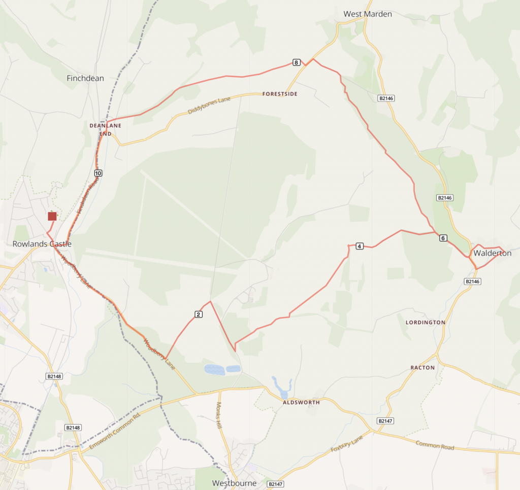
Route overview
A short circular route with a mix of on road sections and bridleways which takes in the pretty village of Walderton.
Route description:
- From Rowlands Castle station turn left towards the village. At the junction go roughly straight ahead and through the arch of the railway bridge on to Woodbury Road following signs to Westbourne and Emsworth
- Carry on along Woodbury Road for just over a mile into the treeline. Take the bridleway sign off to the left by yellow cycle marking bollards (there’s a cycle route opposite). This off-road path runs down a slope and then joins a farm track; carry on to meet the main road. CAUTION: a short, very lumpy section of path downhill from the road has protruding flint stones with sharp edges – and can be slippery.
- At the end of the farm track turn right on to Broadwalk and stay on road for a few minutes, passing the entrance to Stansted House and Gardens. Turn left on to a bridleway, the sign is set back from the road to the left of a metal farm field gate – it’s easy to miss!
- Continue on to the bridleway (Park Lane on map). This old track is fairly flat but narrow and rough in places, and it can get very muddy. Stay on this bridleway for about a mile, passing other path junctions.
- At a crossroads of paths take the left hand path on the byway through the woodland edge. At the end turn right on to Woodlands Lane and follow down the short steep hill to meet the main road.
OPTIONAL DETOUR: A large old round chimney ruin is visible on the skyline to the right. There is informal access to the Racton Ruin (See Note). From Racton Ruin chimney retrace your steps back to point 5 to rejoin the route.
(The alternative is to carry on past the monument, turn left on to the main road and follow for just under a mile and on the bend turn right, signed to Walderton – joining the route at point 7. Caution: This is a faster, busier road.) - Turn right on to the main road for 300m and then turn left into Walderton village centre. The Barley Mow pub is a good refreshment stop.
- Passing the Barley Mow, turn left in to Cooks Lane, which takes you over a small hill through the older part of the village.
- At the main road, turn left for 100m then turn right by a small row of cottages to Woodlands Lane (which you came down earlier). Climb up a short steep hill and on the bend take the bridleway off to the right. As the bridleway forks take the path off to the left.
- The bridleway goes along the edge of a farmer’s field and meets a farm track. Turn right and then left at the next path junction, taking the highest route. Stay on this path until it meets the road.
- Turn left on to Oldhouse Lane and at the next junction turn left on to Finchdean Road (signed Rowlands Castle), and after about a quarter of a mile take the lane to the right. Follow this lane around until it becomes a bridleway and rough surfaced track.
- There is a long downhill stretch on a woodland track which crosses a small road, turn left where bridleway meets farm track by a cottage.
- At the main road junction turn right and follow signs back to Rowlands Castle. The station is on Bowes Hill, first right as you go under the railway arch back into the village.
NOTE: Racton Ruin: This chimney is the known as the Racton Ruin. It is a striking 18th century building with an unknown history and rumours of hauntings. CAUTION: The Ruin is clearly well visited (by heavy-footed ghosts presumably) but access to the site is informal on a rough path off the bridleway.

Distance
11 miles (17.5km)
Time
1.5 hours
Level
easy(ish)
Elevation
Ascent 580ft / 468 calories
Start and End
Rowlands Castle
PlusBike
Planning your combined cycle and rail journey
Travelling by rail with a bike
what are the restrictions?