Route overview
Beautiful Downland views and picturesque old villages on a mix of roads, country lanes and parts of the Shipwrights Way. Great views of Buster Hill and the South Downs.
Route description:
Long Route and Short Route options
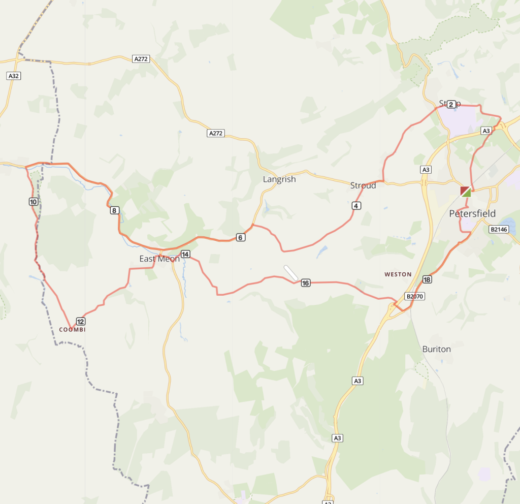
- From Petersfield station forecourt turn right at the Level Crossing on to the main Station Road and after 50 metres then take the first left onto Tilmore Road. Carry on up along this lane, following Shipwright’s Way signs, and at the end of the lane bear right to go over a bridge across the A3.
- Turn right by the Harrow Inn and climb the short but steep wooded hill on Church Road into the village of Steep. All Saints Church is a good recovery spot to get your breath back. Carry on through the village past Bedales School.
- At the crossroads junction with the main road carry on straight ahead on to Ridge Common Lane and continue on to a T-junction.
- Turn right on to the A272 for about 400m and then turn left after the Seven Stars Pub.
- Continue along this road into Ramsdean, and at the triangle turn right to meet the main road, then turn left towards East Meon.
- Carry on past the East Meon turn off and stay this road for approx 3.5 miles to West Meon.
Short Route Option
At point no. 6 Turn left into East Meon village instead of carrying on along the main road. Rejoin the route at point no.9.
- Just before entering West Meon village take a left turn signed for Meon Springs Fishery and stay on this road to Combe.
- At Combe turn left down the hill into East Meon.
- Cycle through East Meon’s old village centre, as the road starts to climb turn left towards Frogmore
- After a mile turn left at Oxenbourne and stay on this pretty single track lane for about 2.5 miles.
- Ignore signs to Weston and turn right to meet the main road and turn left to the roundabout. Alternatively join the footway which is shared use. Caution: Traffic travels fast at this point as it’s just come off an A3 off-slipway.
- From the roundabout follow signs for the Shipwrights Way back to Petersfield. Stay on this road for 1.5 miles. There is a mixture of shared use footway and on-road sections along this road.
- Turn left into Cranford Road and follow Shipwrights Way signs, right onto Grange Road and look for the cycle signage which takes you on a path across the park to join Borough Road. Turn left into the Spain and onto Charles Street, then turn left onto Lavant Street to return to Petersfield Station.

Distance
Long Route: 21 miles / 34 kms Shorter Route: 13.7 miles / 22 kms
Time
1h 20 mins to 2hours
Level
easy
Elevation
Long Route: Ascent 391m / Descent 391m / 840 calories
Shorter Route: Ascent 263m / Descent 263m
Start and End
Petersfield
PlusBike
Planning your combined cycle and rail journey
Travelling by rail with a bike
what are the restrictions?