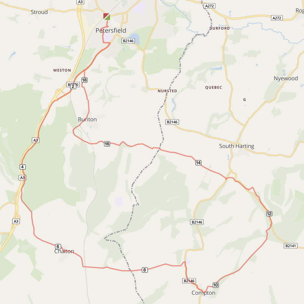
Route overview
A circular route through Queen Elizabeth Country Park on bridleways, quiet lanes and part of the South Downs Way, passing through Chalton and Compton villages. There are some challenging climbs and varied terrain which would suit experienced off-road cyclists, with nice woodland sections and excellent views from the tracks on the South Downs.
Optional detours: Route can be shortened at point 5 and rejoins the route at no.7.
Route description:
- Go down Lavant Street from Petersfield Station. At the crossroads turn right and follow blue cycle signs for the Shipwrights Way to Queen Elizabeth Country Park (QECP). After a couple of miles pass the cycleway signs to QECP and carry on over the Buriton roundabout.
- Look out for a cycleway sign by a metal gate and bollards on approach to the A3 dual carriage way. The path on the disused old A3 route goes up a hill past a quarry and down into QECP.
- From the main entrance to QECP, follow the tarmac drive past the visitor centre and the meadow (there’s a parallel off-road route through the trees to the left of the centre, if you prefer). Where the main drive bears left take the right turn (signed No Unauthorised Access) and continue between outbuildings where the road narrows to become an unsurfaced bridleway. Follow this track along a field boundary for about three quarters of a mile to reach Chalton Lane.
- Turn left and continue towards Chalton.
- Approaching the village up a short climb, turn left at the triangle and continue up the hill before descending steeply to bear left across the railway bridge.
- Don’t follow the road around to the right but continue straight ahead on the unsurfaced Huckswood Lane. Follow this undulating track until you eventually pass Cowdown farm and join a surfaced lane. Turn left where a lane joins from the right and in 200m reach a T junction.
OPTIONAL SHORTER ROUTE: Turn left at junction on to B2146 for about 1/4 mile and take the bridleway northwards for 1km passing a path junction, at the next bridleway junction take the left path and continue on this path through the woods for almost 2km until you join the South Downs Way at Hundred Acres.
Turn right into Compton, then left up Church Lane until it becomes a track. Follow this up and round as it bends to the right, along a woodland boundary. Keep following this track in a north easterly direction, dropping quite steeply down to a road.
- Just before reaching the road, look for a track on the left which follows parallel to the road a short distance to a point opposite the start of a bridleway. Join the bridleway which turns left to follow a field edge, eventually winding uphill through a lovely woodland, Kill Devil Copse, before finally arriving on Harting Down.
- Continue straight ahead to reach the South Downs Way and turn left. This track soon enters a woodland and reaches a road. Cross with care and continue on this track as it descends gently to another road crossing.
- Keep following the well-signposted South Downs Way for about a further three miles. The track surface varies; sometimes tarmac, usually rough chalk.
- On reaching the road crossing, you have the option to either continue ahead on the South Downs Way and return through Queen Elizabeth Country Park, or turn right and follow the road steeply downhill into Buriton village where there are two pubs. From Buriton, follow the clearly marked Shipwrights Way for about three miles back to Petersfield station.

Distance
20 miles (32 kms)
Time
3 hours
Level
challenging
Elevation
1300ft / 840 calories
Start and End
Petersfield
PlusBike
Planning your combined cycle and rail journey
Travelling by rail with a bike
what are the restrictions?