Route overview
A mix of lanes and quiet roads with a few short steep climbs and fun downhills. This takes you through the edge of the leafy Ashford Hangers National Nature Reserve.
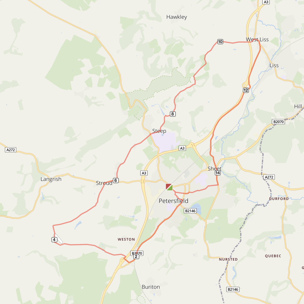
Route description:
- Go down Lavant Street from Petersfield station. At the cross-roads turn right in to Charles Street and follow blue cycle signs for the Shipwrights Way (a 50 miler down to Portsmouth) to Queen Elizabeth Country Park (QECP).
- Continue to follow Shipwrights Way signs down The Causeway south out of Petersfield for a couple of miles, the route is a mixture of on road and shared use cycleway. Keep going until you get to a roundabout.
- Turn right at the roundabout, cycling under the A3 dual carriageway and immediately turn right to Weston & East Meon.
- Don’t go into Weston but take the first left and follow the road for about 1.5 miles, past a pond on your left, before turning right.
- At the grassy triangle in Ramsdean (if you’re passing on a Sunday morning, you may see a queue of locals loitering outside a house. Join them. The artisan baker who lives there sells the best sourdough you’ve ever tasted). Turn right and continue for about a mile to the A272 at Stroud.
- Turn right on to the A272, a busy road, for a few hundred yards and then turn left on a bend into Ridge Common Lane Road.
- Follow to the end of the road and across another crossroads (Owen’s bike shop is here on your left) and into Steep. Just past the village hall, turn left into Mill Lane and carry on along these undulating country lanes, passing a clear stream on your right, for about a mile.
- Bear left passing the sign for Steep Marsh and take the next right turn. Carry on down this steep hill for over a mile until you meet the Hawkley Road.
- Turn right and follow signs to West Liss. By the Spread Eagle Pub turn right again on to the Farnham Road.
Optional: To finish at Liss, turn left here and follow the road for about a mile down to the station. - After passing Hilliers garden centre on the left, join the cycleway alongside the A3.
- Where the cycleway meets a road turn left and cycle through Sheet village centre and past the ancient oak on to Inmans Lane.
- Cross the staggered crossroad junction with the A272 and continue roughly straight ahead into Pulens Lane. This can be a busy and tricky junction.
- Turn right on to Moggs Mead and at the end join the shared use cycleway into central Petersfield and onwards to the train station.

Distance
Distance: Shorter Route - 12 miles
Longer Route: 16 miles
Time
1h 20 mins to 2hrs
Level
moderate
Elevation
Longer route: 675ft. 654 calories
Start and End
Petersfield / Liss
PlusBike
Planning your combined cycle and rail journey
Travelling by rail with a bike
what are the restrictions?