Route overview
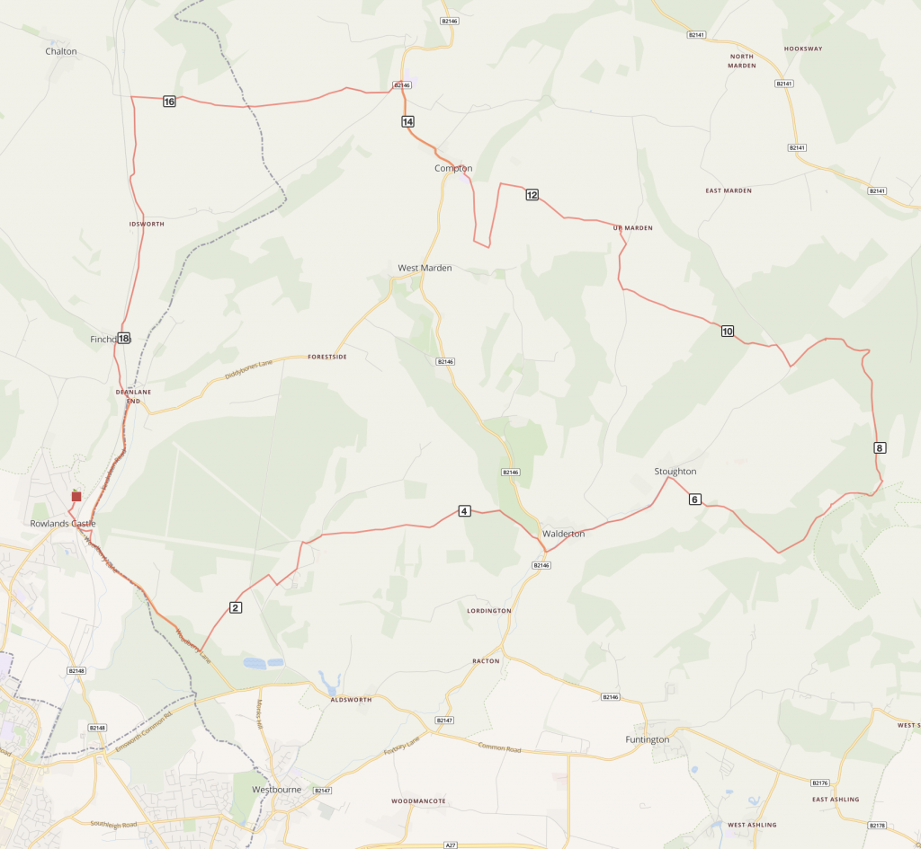
A mix of bridleways, tracks and country lanes in a circular 20 mile route with some very steep climbs and great hilltop views.
Optional detours: Route can be shortened at Stoughton – return leg via Park Lane and Racton Monument. Check measurements.
Route description:
- From the station at Rowlands Castle, turn left to head downhill towards the village. At the junction cross over and under the railway arch onto Woodberry Lane, signposted to Emsworth and Westbourne.
- After about a mile take the bridleway on the left, marked by yellow bollards, and follow this track past a farm and some houses until reaching a road.
- Cross with care and join a bridleway which soon bears right to join a surfaced driveway to Stansted House. Turn left and follow the driveway (refreshments available at Stansted House and Gardens). Continue past the car park entrance and follow the drive then bear left onto a bridleway beside a field edge.
- At the end turn right onto a surfaced road, bear left then take the first right onto a bridleway, Woodlands Lane. This track continues for a mile and a half and descends to reach a road.
- Turn right and ride a short distance to take the first left into Walderton. Continue past the The Barley Mow pub towards Stoughton.
- After a mile, approaching Stoughton, take the bridleway on the right by some farm buildings and climb steadily uphill. After a short distance there is a memorial to a WW2 Polish pilot whose plane crashed in the field on the left. The track becomes steeper towards the summit of the hill. Ignore the first bridleway on the left and continue a short distance to take the next bridleway on the left.
- Follow this track gradually uphill, with views across Kingley Vale to the right, passing The Devil’s Humps, a range of Bronze Age burial mounds, and reaching the summit of Bow Hill with its Trig Point. Shortly after this, at a junction of paths, turn left to go uphill on a steep, narrow track which soon broadens and starts to descend. After a few hundred metres there is a junction of paths.
- Be careful not to follow the obvious forestry track ahead but take the bridleway path slightly off to the left, continuing downhill into the woodland ahead and enjoy the long, sweeping descent which eventually bears left and down to a car park at the road.
- Turn right onto the road for about 300m and take the bridleway on the left. After a short distance look for a right fork to continue on the bridleway up a steep, narrow track (the signpost is hard to see).
- Continue for about a mile until reaching a road. Turn right up the lane towards the hamlet of Up Marden and after 500m take the left turn towards the church. Passing the church and the historic Marden Cart Shed on the left, continue straight ahead onto the narrow bridleway which descends steeply between field boundaries (the surface is rough in places). Climb on a broader track ahead and at the top of the hill turn left at a junction of paths.
- Follow this track gently downhill, with great views of open countryside all around, until reaching a junction. Turn right and continue for about 200m and turn right again onto a bridleway which gradually descends through woodland until reaching the village of Compton (the Tea Rooms serve good cakes and soup).
- At the junction turn right onto the road and continue for about a mile and turn sharp left onto a lane. After a short distance take the turning on the right towards Cowdown farm. Pass the farm and continue on Cowdown Lane which soon becomes a track for a mile and a half until reaching a road junction.
- Turn left signed to Finchdean and Rowlands Castle (also waymarked Sustrans Route 22) and follow this country lane, passing Idsworth Chapel on the left, then going under the railway to reach Finchdean.
- Keep left at the next two junctions to pass under the railway again, bearing right onto Finchdean Road to return to Rowlands Castle. The station is first right after you come through the railway arch yet again.

Distance
20 miles (31km)
Time
3 hours
Level
strenuous
Elevation
Ascent 1440 ft / 845 calories
Start and End
Rowlands Castle
PlusBike
Planning your combined cycle and rail journey
Travelling by rail with a bike
what are the restrictions?